New Orleans
New Orleans, established by the French in 1718, is well known for its rich history,
French Quarter district, unique architecture, jazz and Bourbon Street. My tour of New Orleans included Decatur Street, Jackson Square, Cafe Du Monde, and the French Market; a riverboat lunch cruise on the last steam-powered riverboat, a ride the St. Charles streetcar line, and a twelve block walk along the famous Bourbon Street.
Architecturally, the French Quarter is very well preserved, and spared the fate of many American cities that strove for constant modernization just for the sake of doing so. Many of the buildings had a character and "old world" feel to them that many modern buildings do not.
 |
| The French Quarter is famous for its French-Creole balconies. |
 |
| Another example of French-Creole balconies and well-preserved historic buildings that line the streets of the French Quarter. |
Decatur Street, like many busy streets in historic downtowns, is lined with restaurants, bars, and tourist-trap gift shops. Jackson Square, with the beautiful St. Louis Cathedral in the background, was a pleasant spot to take a break from the busy street. On each side of Jackson Square running along Decatur, are stone pedestrian paths where local artists sold their artwork.
Across the street from Jackson Square, I stopped at the world-famous
Cafe Du Monde, and enjoyed an order of beignets: a fried dough with a very generous covering of powdered sugar. I ended my route along Decatur Street through the
French Market, established in 1791, and still thriving with vendors of all types.
 |
| Inside Jackson Square, off Decatur Street, with the historic St. Louis Cathedral in the background. There is a building ordinance that remains in effect since the colonial era that prohibits the construction any building in the French Quarter taller than St. Louis Cathedral. As a result, the cathedral is the most prominent building in the French Quarter. |
 |
| The world-famous Cafe Du Monde has one of the largest patios I've seen. Earlier, around lunch time, this patio was packed with people. The cafe specializes in beignets, a thick fried dough smothered in powdered sugar. |
 |
| Live street performers can be found throughout the French Quarter. They range from musicians like the ones in this image, dancers, and "living statues" with differing themes. |
While along the waterfront, I boarded the
Natchez, the last remaining riverboat powered by steam, and sailed on the Mississippi River. The second deck dinning room served classic New Orleans dishes including Louisiana fried cat fish, red beans and rice, shrimp creole, and bread pudding. The dinning room also included a live jazz band. While cruising along the Mississippi River, I had to the chance to see the global economy in action. New Orleans is home to one of the
busiest ports in the world.
 |
| New Orleans is strategically located along the Mississippi River, and in close proximity to the Gulf of Mexico. As a result, New Orleans is connected to a 14,500 mile inland water system seving the American Mid-West, and connected to the world's trading system via the Gulf of Mexico. More than 6,000 ocean vessels such as this one pass through the port of New Orleans each year. The large vessel in this image was in the process of transferring pilots by the small boat docked on the vessel's port side. Only American pilots are permitted to navigate the severe twists of the Mississippi River regardless of a vessel's country of origin. |
 |
| The Domino Sugar processing plant. The raw sugar is shipped in from countries such as Brazil and processed here for American markets. To the right, cranes were scooping large amounts of raw brown sugar cane from the barges in the water to be processed at the plant in the background. As a rare exception to an industrial plant, this industrial facility smelled very sweet and pleasant to the nose. |
 |
| In the background is a large oil refining facility. In the foreground is a large tanker vessel which brought imported oil to be refined into gasoline for American markets. |
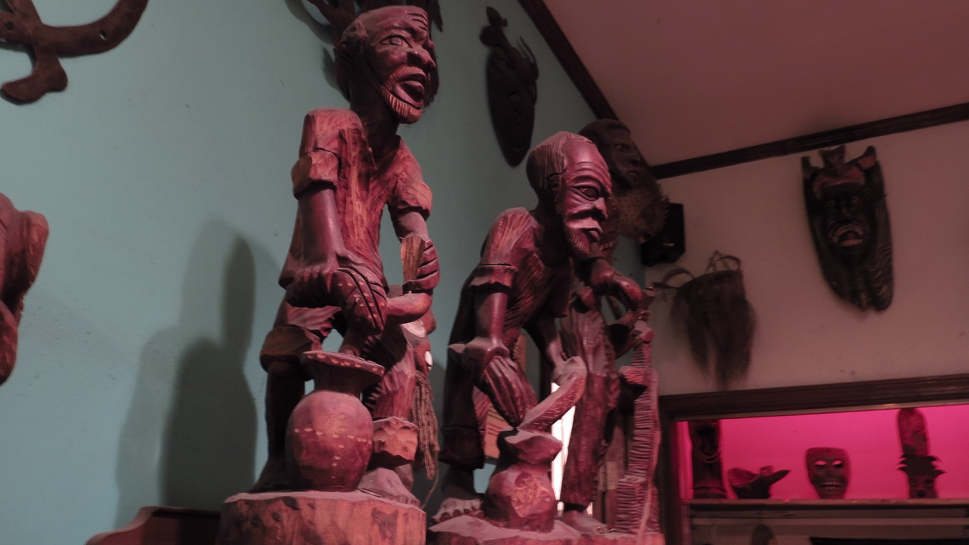
A visit to New Orleans would not be complete without a visit to a Voodoo museum. During the colonial era, some enslaved Africans brought their traditional voodoo folkways with them to colonies such as French Louisiana. Over time, African voodoo syncretized with Catholicism and French folkways, resulting in voodoo traditions distinct from their African counterparts.
New Orleans Historic Voodoo Museum, although only two rooms, houses informative and fascinating exhibits on Louisiana voodoo folkways.
 |
| Traditional African tribal masks. |
 |
| Voodoo practitioners often make folk art depicting voodoo practices such as this one. Styles vary by continent of origin, era, and preferences of the artist. |
 |
| The museum exhibit explains that voodoo dolls are typically made for positive purposes, and usually represent the maker, contrary to popular belief. Although they can be used for evil. The voodoo practitioner will make their voodoo doll from local materials at hand, and will add something from their body or from a person it is to represent. In the New Orleans region, Spanish moss and Cyprus sticks are common materials for making voodoo dolls because they are readily available. |
Bourbon Street is where most people go to party. In the evening, the police close Bourbon Street to car traffic to make more room for the increasing number of tourists, street performers, hustlers, and inebriated pedestrians. The historic buildings are almost completely occupied by a few restaurants, many bars, and about a half dozen "gentleman's" clubs. As I walked along the street, some of the street performers appeared to be talented, and together, they in part bring the street to life. Others were simply hustlers trying to make a quick buck of gullible tourists, and they didn't mince words when I promptly rejected their "sales" pitches.
 |
| Looking down Bourbon Street from a French balcony. |
 |
| Bourbon Street is closed to auto traffic at night to make more room for pedestrian traffic. The street is dominated by bars, "gentleman's" clubs, and tourist-trap souvenir shops. |
Louisiana Swamps and Bayous
Physical landscapes appeal to the eye in different ways, and impact how people live. Louisiana's swamps and bayous are truly a unique sight to see, and the ways a physical environment shape how humans live are evident.
I toured two swamps in Louisiana's Florida Parishes and Greater New Orleans natural regions. I started out with a self-guided nature trail in the swamps of Northlake Nature Center. A good portion of the trail is raised on low boardwalk, which provided access deep within the swamp habitat.
For my second swamp tour, I boarded an air-boat and traveled deep within the swamps that would be impossible to access any other way. The air-boat ride combined both adventure, navigating the swamps at high speeds with the air-boat's Corvette engine, and stopping at points deep within the swamp to learn about the nature around me.
 |
| The air-boat was equipped with a Corvette engine. For part of the tour, we sped along at high speeds through the swamp. |
 |
| Deep withing the swamp. Part of the tour was educational. It was in this enclave that we learned that this section of the swamp had been significantly impacted by human activity, and some of what is seen in this image actually does not naturally grow in the swamp environment. The large oak trees with Spanish moss hanging from the branches, and the palm trees are not natural to the swamp. The oak trees are possible due to soil deposits from human activity, and the palm trees were imported by the Spanish and French. |
 |
| There were many alligators in the swamp. When the air-boat stopped, within minutes we were surrounded by approximately six alligators. The pilot was feeding them marsh mellows in this image. Marsh mellows do not hurt them, and they do not fill their stomachs, so they do not become dependent on humans to feed them. |
 |
| This section of the swamp is natural, and appears as it would have prior to Euro-American impact. The swamp consists mostly of submerged grasses, and only two species of tree, Cyprus and Tupelo, which can grow in submerged soil. |
Louisiana's
bayou region is geographically vast, therefore, I planned two separate driving tours deep within the bayou region, eventually reaching the Gulf of Mexico (
Driving Tour #1) (
Driving Tour #2). The highway routes ran parallel to the bayous, where I had the chance to see how people live in bayou country. As I made my way south, I witnessed the landscape slowly transform from bayou surrounded by development on stable land, to expanding bayou mixed with wetlands. Development patterns became more sporadic, and the distinction between land and water became blurred. The roads were raised for greater distances, sometimes for miles due to the lack of stable land. When the road was not raised, it was narrow and had many dips . Each side of the road had large rocks protruding to help slow soil erosion, due to the water level, which was almost equal to the road on both sides.
 |
| Heading south-bound on I-55. Because of the vast swamp and bayou landscape below, the interstate highway was elevated for over 38 miles. |
 |
| The bayou along LA-1. Communities are built right along the bayou where stable ground is located. The shrimp boats in this image were a common sight along the bayou. Most shrimp boats were docked right in the owner's backyards like the ones in this image. In the background, behind the shrimp boats, houses can be seen. |
 |
| Farther south along LA-1, the landscape transitions from bayou cutting through solid ground, to vast, open waterways and marshland. Far in the background, to the left, are large maritime shipping facilities and oil complexes. |
 |
| More elevated highway to allow travel between sporadic, solid ground. Even the side streets, like the one in the distance to the right, are elevated. |
 |
| This 15-20 mile section of LA-1 is no longer elevated. Rather, it is paved near sea level. Water and marsh flanked both sides of the road for miles. On each side, rocks are placed to help slow erosion of the narrow soil bed the road is paved upon. |
 |
| The town of Grand Isle, near the terminus of LA-1, and near the point where the bayou and wetlands gives way to the Gulf of Mexico. All the buildings, residential, commercial and civic, are raised above ground due to constant threat of storm surges from tropical storms and hurricanes. The body of water the foreground is the Caminada Bay; the body of water behind the buildings is the Gulf of Mexico. |
Week Three: Mobile, Alabama and Surrounding Regions


No comments:
Post a Comment